People who are blind or visually impaired live and use cities, but they could enjoy them and take advantage of them more if they had the ability to circulate autonomously and safely. To do this, they must be able to orient themselves and avoid obstacles and risks of all kinds. Among them we can highlight those that are derived from vehicle traffic, unevenness or gaps without marking or protecting and projections or elements that invade the passage area at a height not detectable with the poles that are usually used.
To warn and avoid these barriers and dangers, these people use different techniques and strategies that allow them to move around the city alone. To do this, they maximize the perceptible information, mainly through the ear, the contrasts of light when possible and the combination of touch and movement of the limbs thanks to the use of canes.
The characteristics of the urban layout and design make a decisive contribution to guiding and preventing hazards. For this, the pedestrian areas must have a simple and logical layout in the routes, crossings and elements, so that their interpretation, memorization and prediction are facilitated.
The unevenness between the road and the sidewalk has acted, on the other hand, as a longitudinal guide and as a protective border to avoid the danger of invading, unconsciously, the vehicular circulation space. This unevenness has been progressively eliminated at pedestrian crossings in cities, in order to improve general mobility and remove barriers for people with mobility disabilities, especially wheelchair users. This also eliminates for visually impaired people the possibility of detecting the limit of the safe zone to circulate.
There are urban design solutions that are increasingly used, such as shared space streets or single platform streets, which are seeking precisely to eliminate any delimitation between pedestrian and vehicular use areas. This is good for pedestrians in general and for those who circulate in a wheelchair in particular because they do not have any unevenness to bridge in their circulation. But for the same reason, orientation is difficult for people who lack the sense of sight. Thus, improvements for some would be compromising the security and autonomy of others.
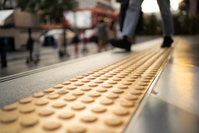
To avoid this, since the 1960s, some countries began to install tactile pavements, which by means of low or high relief shapes served to transmit orientation and safety information to these people. These pavements became generalized from the 1980s on to European countries, the United States, and our country Australia, beginning by marking the edges of railroad platforms and other uneven limits.
The transmission of this information also raises technical problems: people with visual disabilities show very different capacities to interpret their surroundings to orient themselves and move safely through the city. Not only the characteristics of their limitation, but other aspects such as their educational level, acquired abilities, the age of the disability or the type of training received will determine the possibilities of interpreting signals and stimuli that allow their autonomous circulation in the city.
For this reason, it has become necessary to reduce the elements of this language to a minimum by using two main types of tactile pavements, which are easy to identify and which form the basis of a simple signaling language. One is made up of a surface of buttons (truncated domes, truncated pyramids or cylinders) and the other of a surface of bands along its entire width. For example is tactile strips from aluminium. Both can help blind people follow a particular path by using their feet and cane to detect and distinguish their raised patterns on the pavement.


